


Argo - Boat Navigation App
4.2431.00 Reviews
App Specs
- Version
- 3.10.0
- Updated On
- License
- Free
- Downloads
- 100,000+
- Developer
- Argo Technologies, LLC
- Categories
- Maps & Navigation
- Platform
- Android
Screenshots
 Analysis by AppCompare
For a first boating trip with a navigation app, I’d want a clear path from opening the map to planning a route I can actually use. Argo is built around that kind of practical outing: it brings chart viewing, trip planning, logging, and sharing into one place. I find that combination more useful for a day on the water than a map app designed mainly for roads, though it doesn’t replace sound judgement, local knowledge, or proper safety equipment.
Argo is a free boating and navigation app from Argo Navigation, LLC, with optional in-app purchases ranging from $2.99 to $39.99 per item. It has a 4.0 average from around 1,000 ratings, and more than 100,000 installs. The Everyone age rating makes it broadly accessible, while the purchase range is worth checking before committing to any paid extras. The app’s focus is North American boating, so I’d consider that before relying on it for a trip elsewhere.
What to expect on your first launch
The first thing I’d do is treat Argo as a planning companion, not as an authority that can make every decision for me. Its map is the centre of the experience, and the broader appeal is being able to plan, log, and share boating trips without switching between several unrelated tools. If you’re used to a road-navigation app, the change in perspective is important: a boat trip depends on the waterway and conditions, not simply on the shortest route between two points.
The current version is 3.0.0, and the app requires Android 7.0 or later on Android devices. The listing also identifies it as available for Android and iOS. I’d start by checking that my device meets the requirement, then open the map somewhere familiar rather than beginning with an ambitious trip. That small choice makes it easier to understand what the screen is showing and where route planning fits.
Set up around a familiar outing
For a first session, I’d choose a route I already know, or at least a short outing with an obvious starting point and destination. I’d look over the map, identify the places I intend to use, and plan the trip before heading out. This is more reassuring than trying to learn the controls while also handling a boat, passengers, and changing conditions. If I’m going with someone else, I’d discuss the intended route on shore so we share the same expectations.
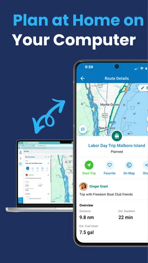
A useful habit is to think of the app’s trip tools as a before-and-after routine. Before leaving, use the map and route planning to organise the outing; afterward, use the trip log and sharing options to keep a record or pass along the experience. That makes the app relevant even when I’m not actively navigating. It also gives a new user a manageable first goal: prepare one simple outing, then decide whether the logging and sharing side suits their habits.
Your first meaningful success
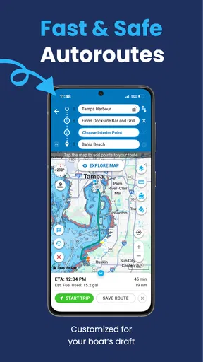
I’d count a first planned outing as a success when I can open the map, make sense of the route I intend to take, and explain that plan to the people aboard. Estimated travel times can help with organising the day, but I would treat them as planning guidance rather than a promise. Conditions, speed, and decisions made on the water can change how long a trip takes, so I’d leave room in the schedule instead of building a tight timetable around an estimate.
Worth Reading Before You Choose

EA SPORTS FC Mobile 26 Is a Bigger Football Game, but It Takes Time

Flipboard Shows What News Apps Must Do Beyond the Feed

Switching to Android Auto Means Rethinking Your Driving Routine

Google Calendar Makes a Crowded Week Easier to Manage

Ludo King Makes the Most of the Minutes Between Plans

Baby Panda World Brings Quick Play to Modern Phones, but Its Game Library Feels Busy
After the trip, logging it gives the plan a useful second life. A record can help me remember where I went and make it easier to share the outing with other boaters. My practical tip is to add that record while the route is still fresh in my mind, rather than waiting until I can no longer recall the small details that made the trip enjoyable or difficult.
Weather, tides, and responsible use
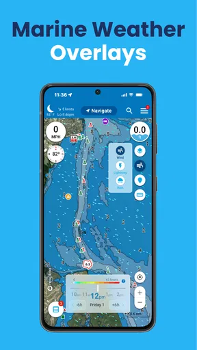
Weather information and tide charts are among the tools that make Argo feel more tailored to boating than a general-purpose map. I’d check them while planning, then make a fresh judgement before departure instead of treating a screen as a guarantee that conditions will remain safe. A change in weather can matter more than a convenient route, and tide considerations can affect whether a planned outing makes sense at a particular time.
I also wouldn’t treat an app’s emergency-related tools as a substitute for a float plan, suitable safety gear, or knowing how to contact help independently. If I’m boating with others, I’d tell someone ashore where we expect to go and when we plan to return. The best use of digital tools is to support preparation and awareness, not to encourage me to take risks because I have a phone in my pocket.
When Argo fits, and when it doesn’t
Argo is a natural fit for recreational boaters who want trip planning and a record of their outings in one app, especially people who enjoy exchanging recommendations with other boaters. The social side may be particularly appealing if I’m exploring unfamiliar places and like learning from other users’ suggestions. It can also suit a casual weekend user who wants more boating context than a road map offers without turning trip planning into a complicated project.
I’d be more cautious about relying on it as my only navigation resource for demanding or unfamiliar conditions. A dedicated chartplotter or another specialist navigation setup may be a better primary tool for someone who needs a particular onboard workflow or is making a serious passage. Likewise, if I only need to find a road route to a marina and never plan or record time on the water, an ordinary map app may be simpler. Argo’s value is in its boating focus, so it makes less sense when that focus isn’t useful to me.
Small habits that make the app more useful
One non-obvious benefit of planning a known route first is that it gives me a practical way to judge the app’s map and workflow before I depend on them for an unfamiliar trip. I can compare what I see in the app with what I already understand about the outing, note what feels clear, and identify anything I need to check elsewhere. That is a better learning exercise than testing the interface for the first time far from shore.
I’d also separate route planning from route sharing. A plan is useful for making decisions before a trip; a shared record is useful for remembering and communicating what happened afterward. Keeping those purposes distinct helps avoid treating a social recommendation as automatically suitable for my boat, timing, or conditions. Other users can point me toward ideas, but I still need to assess whether a suggestion fits my own outing.
There is a trade-off in bringing planning, logging, and community into one app: convenience comes with more choices to learn than a basic map needs. If I only want a quick look at a location, I may not need to explore every part of the experience. I’d learn the map and route workflow first, then try logging and community features once I know they would add something to my routine.
Practical expectations and common questions
A first-time user may wonder whether the app is free to try. Argo is free to download, while in-app purchases are available; I’d review the purchase details in the app before buying anything and decide whether an extra is relevant to how I boat. The listed price range runs from $2.99 to $39.99 per item, so I wouldn’t assume every feature or option is included at no cost.
Another sensible question is whether it works for a trip outside North America. Its stated focus is North American charts, so I’d choose a navigation tool designed for the region I’m visiting rather than assume Argo is equally suited to every coastline. And if my phone has limited connectivity, I’d avoid making assumptions about what will remain available: I’d check the map and trip information I need before leaving, and carry appropriate backup navigation resources.
The app’s version and platform requirements are also worth a quick check before planning around it. Android users need version 7.0 or later, while iOS users can find the app for Apple devices. I’d install it and explore the map at home or at the dock first, when I have time to understand the interface rather than trying to troubleshoot during departure.
When it comes to hitting the open water, having the right navigation tool can make all the difference. That's where Argo comes into play. Let me take you on a journey through my experience using this nifty app that has quickly become a staple for boating enthusiasts.
Setting Sail with Argo
First things first, downloading and setting up Argo is a breeze. Available for both Android and iOS, it’s just a few taps away from being your digital co-captain. Once installed, I was greeted with an intuitive interface that made navigation feel less like a chore and more like an adventure.
User-Friendly Interface
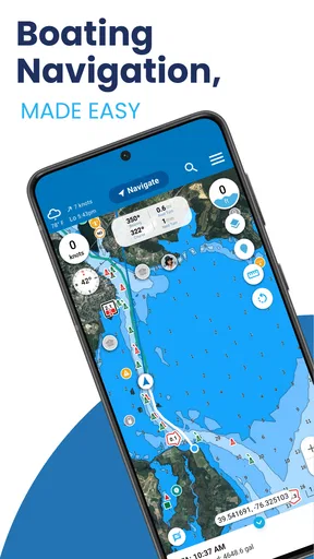
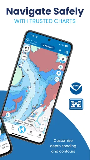
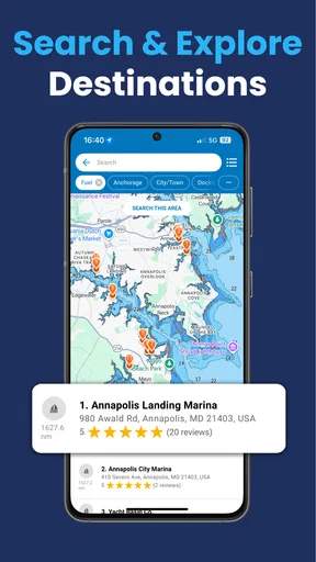
The design is sleek, and the functionality is pretty straightforward. I didn’t need to spend much time figuring out where everything was. The map is at the heart of the app, and it’s both detailed and easy to read. No more squinting at tiny text while trying to keep an eye on the waves!
Features That Stand Out
One of the things I love about Argo is its real-time weather updates. Knowing what’s happening weather-wise is crucial when you’re out on the water. The app provides timely information that helps you plan your trip and avoid unexpected storms. Plus, the tide charts are a fantastic touch for those of us who like to plan around the perfect conditions.
The route planning feature is also top-notch. You can chart your course with ease, and the app provides estimated travel times, which is super handy for longer trips. It’s like having a personal navigator right in your pocket.
Community and Connectivity
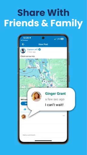
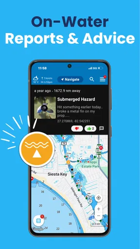
Another aspect that I found really engaging is the community feature. You can connect with other boaters, share tips, and even discover new spots. It’s like a social network but for boat lovers. I’ve found some hidden gems thanks to other users’ recommendations, which has definitely enriched my boating experience.
Staying Safe on the Water
Safety is paramount, and Argo has you covered. The app offers emergency contact features that can connect you with local authorities should you ever find yourself in a bind. It’s reassuring to know that help is just a tap away.
Performance and Reliability
In terms of performance, Argo runs smoothly without any hiccups. I’ve yet to experience any crashes or lag, even when I’m out of range of a strong signal. The app seems optimized to work well even in less-than-ideal conditions, which is a huge plus. After all, the middle of the ocean isn’t exactly known for stellar Wi-Fi!
Room for Improvement
While Argo is fantastic, there's always room for a few tweaks. For instance, the addition of more personalized customization options would be a nice touch. Being able to tailor the interface to suit individual preferences could make the experience even more seamless.
Additionally, expanding the database of locations could help users discover even more cool spots to explore. But these are minor quibbles and don't detract from the app's overall excellence.
In conclusion, Argo is a must-have for anyone who loves the open water. It's not just a navigation tool; it's like a comprehensive boating companion that enhances every aspect of your trip. Whether you're a seasoned sailor or a weekend warrior, this app caters to all levels of experience.
With its user-friendly interface, robust features, and strong community aspect, Argo stands out in the sea of navigation apps. So, if you haven't yet, give it a try. It might just become your new favorite co-captain!
Pros
- Intuitive user interface for easy navigation.
- Comprehensive offline maps available.
- Real-time weather updates included.
- Customizable route planning features.
- Supports multiple languages for global use.
Cons
- High battery consumption during use.
- Limited free features in the basic version.
- Requires internet for certain functionalities.
- Occasional lag in map loading.
- Subscription cost may be high for some users.
FAQs for Argo - Boat Navigation App
What features does Argo offer for boat navigation?
Argo provides a comprehensive suite of features designed for boat navigation, including real-time GPS tracking, route planning, and weather updates. The app also offers social networking capabilities, allowing users to share their routes and favorite spots with other boating enthusiasts. Additionally, Argo includes offline maps, ensuring you stay on course even without internet access.
Is Argo compatible with both Android and iOS devices?
Yes, Argo is available for both Android and iOS platforms. Users can download it from the Google Play Store for Android devices and the Apple App Store for iOS devices. The app is optimized for a wide range of smartphones and tablets, ensuring a seamless user experience across different devices.
Does Argo require an internet connection to function?
While Argo offers offline maps for areas with limited connectivity, some features, such as real-time weather updates and social sharing, require an internet connection. It's advisable to download necessary maps in advance if you plan to venture into areas where internet access may be unreliable.
How user-friendly is the Argo app for beginners?
Argo is designed with a user-friendly interface that caters to both novice and experienced boaters. The intuitive design ensures easy navigation through the app's features, with clear instructions and helpful guides. Beginners will find the app straightforward to use, making it a reliable companion for boating adventures.
Are there any subscription fees or in-app purchases in Argo?
Argo offers a free version with basic features, but for access to premium features such as advanced weather tools and enhanced social functionalities, users may need to opt for a subscription. The app provides a clear breakdown of costs, allowing users to decide if the premium features align with their needs.


